 |
|
Ecological Regions & Subdivisions of Uvalde County, Texas
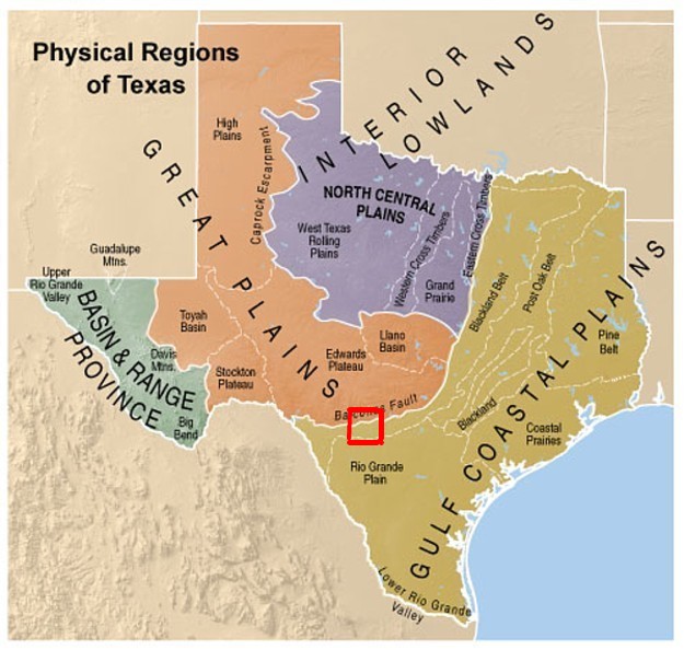
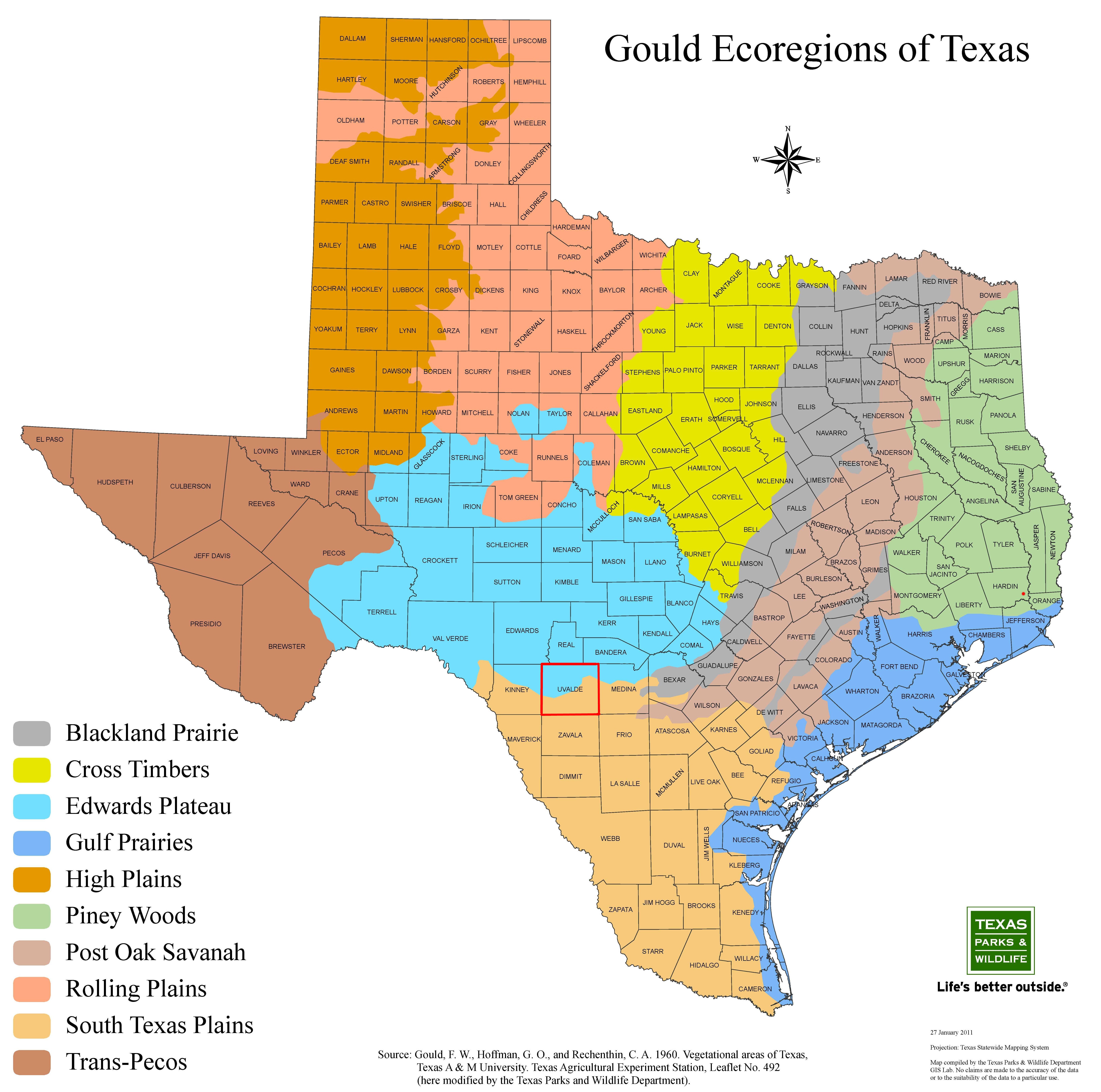 Edwards PlateauThe Edwards Plateau region comprises an area of West Central Texas commonly known as the “hill country.” It is bounded on the east and south by the Balcones Fault. To the north it extends to the Western Cross Timbers of the Oak Woods and Prairies region and grades into the Plains regions. The Pecos River and eastern edge of the Stockton Plateau define the western extent of the Edwards Plateau region. Elevations range from slightly less than 100 feet to over 3 ,000 feet. Several river systems dissect the surface, creating a rough and well-drained landscape. Average annual rainfall increases from west to east, ranging from 15 to 33 inches. Seasonal rainfall patterns peak in May/June and in September. Soils of the Edwards Plateau are usually shallow with a variety of surface textures. They are underlain by limestone. Man-made lakes, ranches, and farms are scattered throughout the region. Scrub forest is the most characteristic plant association of the area. Ash, juniper, Texas oak, and stunted live oak are dominant in the more dissected southern and eastern canyonlands of the region. Mesquite occurs throughout the Edwards Plateau; together with live oak, it dominates the wood vegetation in the west. Some savanna type vegetation also occurs and was formerly more widespread. According to Correll and Johnon, the most important climax grasses of the Plateau include switchgrass, several species of bluestems and gramas, Indian grass, Canada wild-rye, curly mesquite and buffalo grass, with the rough, rocky areas typically supporting a tall or mid-grass understory and a brush overstory complex made up primarily of live oak, Texas oak, shinnery oak, junipers and mesquite. The northwestern portion of the Edwards Plateau transitions into “mesquite-tobosa country” similar to that of the Rolling Plains, whereas the Stockton Plateau portion supports the shorter vegetation of semi-desert grassland (Correll and Johnson). Throughout the region, the brush species are generally considered as “invaders” with the climax largely grassland or open savannah, except on the steeper, rockier canyon slopes which have continually supported a dense cedar-oak- thicket. The Plateau is a region of high endemism, such as netleaf forestiera (Forestiera reticulata), plateau milkvine (Matelea edwardsensis), basin bellflower (Campanula Reverchonii), Lindheimer crownbeard (Verbesina Lindheineri), Lythrum ovalifolium, Tridens Buckleyanus, twisted-leaf yucca (Yucca rupicola), sotol (Dasylirion heteracanthium ), bracted twist-flower (Streptanthus bracteatus ) and cliff bedstraw (Galium Correllii) (Correll and Johnson). In addition to endemism, the Plateau flora reveals a close relationship to that of Mexico (Correll and Johnson). Included in the Edwards Plateau
is the Llano Uplift area. Geologically the region is a large dome with rolling to hilly topography. Granite exfoliation domes,
the largest of which is known as Enchanted Rock, are common. In contrast to the clays and clay loams of the Edwards Plateau,
sandy soils predominate on the Llano Uplift. Rainfall averages about 30 inches, peaking in May or June and September. Oak
and oak-hickory woodlands are common vegetational types, along with mesquite savanna and some grassland types that were once
more widely distributed. The Savanna occurs on loamier soils underlain by caliche. South Texas PlainsThe South Texas Plains, also known as the Rio Grande Plains or Tamaulipan Brushlands, consists of about 20,000,000 acres. Topography is level to rolling. Elevations range from 1,000 feet to about sea level. Soils of the South Texas Brush Country are clays and clay loams. Soil reactions vary from alkaline to slightly acid. The average annual rainfall of 16 to 35 inches, increasing from west to east. Average monthly rainfall is lowest in January and February, and highest during May or June. After a midsummer depression, another peak is reached in September. Summer temperatures are high, with extremely high evaporation rates in the Laredo area. Thorny brush is the predominant vegetation type in the region, including mesquite, acacia, prickly pear, and mimosa, among others. Areas of shallow soils and rapid drainage generally support this plant life. A grassland or savanna type vegetation which also occurs was somewhat more extensive in the 19th century and earlier, but long continued grazing and other factors have altered the plant communities to such a degree that ranches of the region now face a severe brush problem. According to Correll and Johnson, there are distinct differences in climax plant communities and successional patterns on the various range sites, with the characteristic grasses of the sandy loam soils being seacoast bluestem, species of Setaria, Paspalum, Chloris and Trichloris, silver bluestem and coast sandbur (Cenchrus incertus) and the dominants on the clay and clay loams are silver bluestem, Arizona cottontop (Trichachne californica), buffalo grass, curly mesquite (Hilaria Belangeri) and species of Setaria, Pappophorum and Bouteloua. He describes the low saline areas as characterized by gulf cordgrass ( Spartina spartinae ), seashore saltgrass and sacaton (Sporobolus Wrightii). whereas the grasses of the oak savannahs are mainly seacoast bluestem, Indian grass, switchgrass, crinkle-awn (Trachypogon secundus) and species of Paspalum. On the rolling open or brush-covered hills, the Malvaceae are also abundantly represented here as well as in the coastal area (Correll and Johnson). The Brush Country has a greater diversity of animal life than any other in Texas.
It is home for many near tropical species which abound in Mexico, many grassland species that range northward, and some desert
species commonly found in the Trans Pecos. 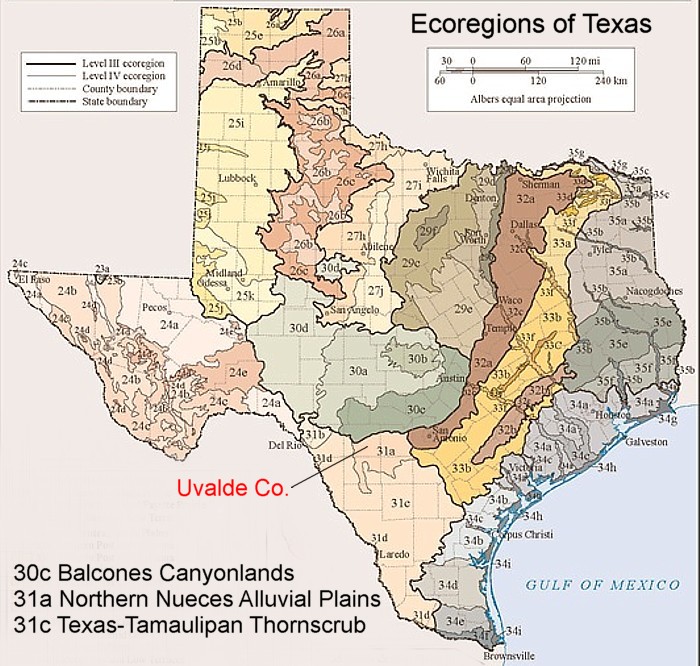
30c The Balcones Canyonlands: This ecoregion forms
the southeastern boundary of the Edwards Plateau (30). The Edwards Plateau was uplifted during the Miocene epoch at
the Balcones Fault Zone, separating central Texas from the coastal plain. The Balcones Canyonlands are highly dissected
through the erosion and solution of springs, streams and rivers working both above and below ground; percolation through the
porous limestone contributes to the recharge of the Edwards Aquifer. High gradient streams originating from springs
in steep-sided canyons supply water for development on the Texas Blackland Prairies (32) at the eastern base of the
escarpment. Ecoregion 30c supports a number of endemic plants and has a higher representation of deciduous woodland
than elsewhere on the Edwards Plateau (30), with escapment black cherry, Texas mountain-laurel, madrone, Lacey oak, bigtooth
maple, and Carolina Basswood. Some relicts of eastern swamp communities, such as baldcypress, American sycamore, and
black willow, occur along major stream courses. It is likely that these trees have persisted as relics of moister, cooler
climates following the Pleistocene glacial epoch. Toward the west, the vegetation changes gradually as the climate becomes
more arid. Plateau live oak woodland is eventually restricted to north and east facing slopes and floodplains, and dry slopesare
covered with open shrublands of juniper, sumac, stool, acacia, honey mesquite, and ceniza.
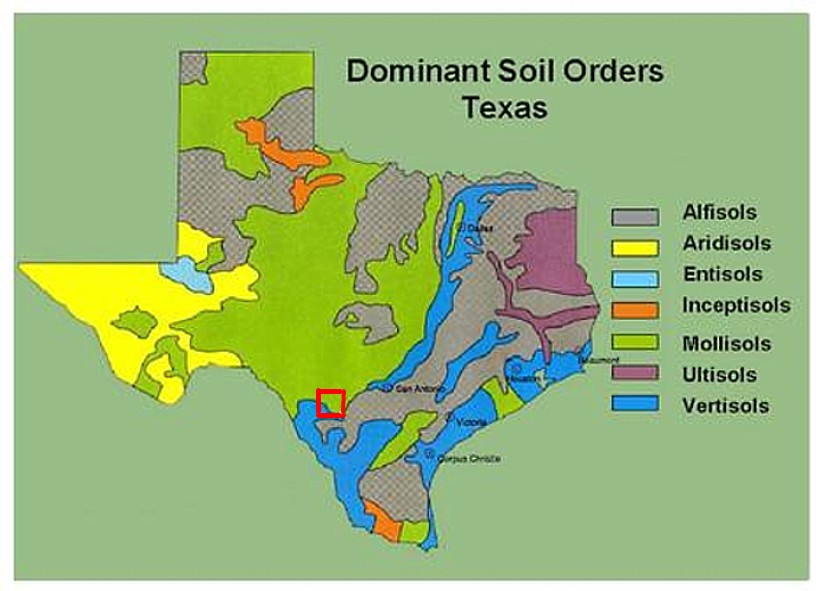
31a The Northern Nueces Alluvial Plains: This ecoregion differs from much of ecoregion31 due to greater precipitation (22 - 28 in.), numerous streams that flow from the Balcones Canyonlands (30c), transitional vegetation patterns, mosaic of soils and surficial materials, and land cover that includes more cropland and pasture. Broad Halocene and Pleistocene-age alluvial fans and other alluvial plain deposits characterize the region. The region has a hyperthermic soil temperature regime with aridic ustic and typic ustic soil moisture regimes. Soils are mostly very deep, moderately fine-textured and medium-textured. Mollisols and Alfisols are typical, with some Inceptisols. General vegetation types include some mesquite-live oak-bluewood parks in the north, and mesquite-granjeno parks in the south. Some open grassland with scattered honey mesquite, plateau live oak, and other trees occur. Little bluestem, sideoats gramma, lovegrass tridens, multiflowered false rhodegrass, Arizona cottontop, plains bristlegrass, and other mid grasses are dominant on deeper soils. Open grassland with scattered low-growing brush, such as guajillo, blackbrush, elbowbush, and kidneywood, characterize shallower soils. Arizona cottontop, sideoats grama, green sprangletop, and false rhodegrass are dominat midgrasses on these soils. Some floodplain forests may have hackberry, plateau live oak, pecan and cedar elm, with black willow and eastern cottonwood along the banks. Cropland is common, but large areas are used as rangeland. The main crops are corn, cotton, small grains, and vegetables. Most cropland areas are irrigated. Hunting leases for white-tailed deer, northern bobwhite, and mourning dove are an important source of income. 31c Texas-Tamaulipan Thornscrub: This ecoregion covers a large portion of the Southern Texas Plains and encompasses a mosaic of vegetation assemblages and a variety of soils. This South Texas region owes its diversity to the convergence of the Chihuahuan Desert to the west, the Tamaulipan thornscrub and subtropical woodlands along the Rio Grande to the south, and coastal grasslands to the east. Composed of mostly gently rolling or irregular plains, the region is cut by arroyos and streams, and covered with low-growing vegetation. The thorn woodland and thorn shrubland vegetation is distinctive, and these Rio Grande Plains are commonly called the "brush country". Three centuries of grazing, suppression of fire, and droughts have contributed to the spread of brush and the decreases of grasses. Soils include hyperthermic Alfisols, Aridisols, Mollisols, and Vertisols. They are varied and complex, highly alkaline to slightly acidic, ranging from deep sands to clays and clay loams, Caliche outcroppings and gravel ridges are common. Precipitation is bimodal, with peak rainfall occurring in spring and fall. Spring rains are the result of frontal activity, while fall precipitation is usually tropical in origin. Typically, transpiration and evaporation far exceed input from precipitation. Precipitation is erratic, with extreme year-to-year moisture variation. Droughts are common and frequently severe. The vegetation is dominated by drought-tolerant, mostly small-leaved, and often thorn-laden small trees and shrubs, especially legumes. The most important woody species is honey mesquite. Where conditions are suitable, Texas persimmon, lotebush, granjeno, kidneywood, coyotillo, Texas paloverde, anacahuita, and various species of cacti, Xerophytic brush species, such as blackbrush, guajillo, and cenzia, are typical on the rocky, gravelly ridges and uplands. The brush communities also tend to grade into desert scrub near the Rio Grande. Mid and short grasses are common, including cane bluestem, silver bluestem, multiflowered false rhosegrass, sideoats gramma, pink pappusgrass, bristlegrasses, lovegrasses, and tobosa. Most of the area is rangeland and large ranches raise beef cattle. Ranching income is supplemented with hunting leases. Northern bobwhite and white-tailed deer are important game species. Hunting also occurs for mourning doves, wild turkey, and collared peccary. Cultivated land is minimal, with mostly sorghum, small grains, cotton, and watermelons.
Map 7 (Below): Soils of Uvalde County, Texas. 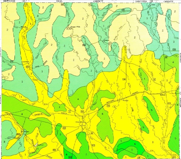 The six major soil associations of Uvalde County:
1) Uvalde-Knippa-Montell asociation (Nearly level to gently sloping, deep loamy and clayey soils) 2) Rock land-Real-Eckrant association (Exposed limestone bedrock and nearly level to gently sloping and undulating to steep, shallow to very shallow and gravelly, loamy and clayey soils) 3) Ector-Eckrant-Speck association (Nearly level to gently sloping and undulating to hilly, very shallow to shallow and stoney, clayey and loamy soils) 4) Olmos-Ector association (Undulating, shallow and very shallow and stony and gravelly, loamy soils) 5) Hindes-Yologo-Olmos association (Undulating, deep to very shallow gravelly loamy soils) 6) Webb-Zavco-Duval association (Nearly level to gently sloping, deep loamy soils) |
|
|
|